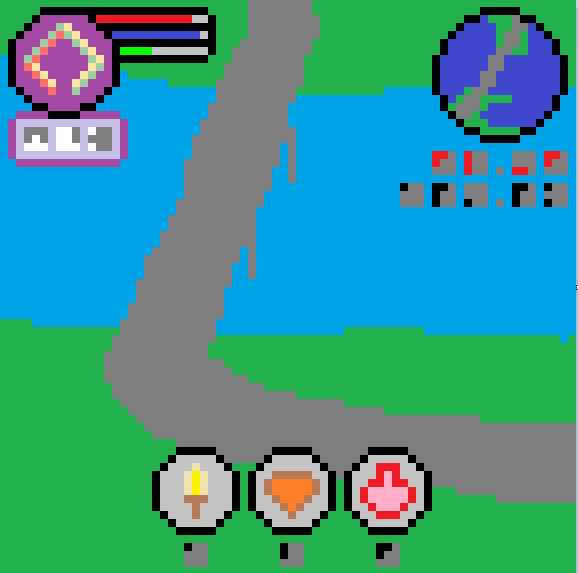
I think this is
Auckland Harbour Bridge
at
(-36.83, 174.75)
and the (8,3,7) solution is
AUCKLAND NEW ZEALAND.
You can see
the bridge and its immediate environs in the circle at top right, and (in a rather different view) in the large image -- though I'm not sure what view would show you the curve in the southern road without also showing the protruding jetty/pier/whatever-it-is that's visible in the inset. Maybe it's a post-apocalyptic game set in a future where that jetty/pier/whatever is underwater? [OP clarifies that this is just a minor inaccuracy in drawing and not significant.]
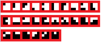
The 3x3 grids are
digits, as follows:
... 0    #.. 1    #.. 2    ##. 3    ... 4
...      ...      #..      #..      ...
...      ...      ...      ...      #..

#.. 5    #.. 6    ##. 7    ... 8    #.. 9
...      #..      #..      ...      ...
#..      #..      #..      ##.      ##.
which we may explain
by supposing that cells in the first two rows count 1 and cells in the bottom row count 4, but as we'll see that's not exactly the right rule.
The grids at top right
give northings and eastings; the northings are red because they are negative, New Zealand being in the southern hemisphere [citation needed].
Now, what about the 3x3 blocks at top left?
It seems likely that they say PSE somehow. The third is a 5, strongly suggesting A1Z26, and I think the intended rule is that the scoring goes as follows:
114
144
444
.
Then
the blocks indicate the numbers 16, 19, 5, which is exactly what we need to make PSE. (Note: in the original version of the puzzle there was a minor error that made this not quite work, but it's been fixed now.)
The bars at top left
look like they measure 12, 11, 4 pixels respectively. Again A1Z26 yields nothing useful (LKD) and if there's useful information here I'm failing to see what it is. [OP clarifies in comments that they're just window-dressing.]


