10
$\begingroup$

We have been through a lot with Dave. Lately, he is a bit strange. He always looks like he's trying to tell me something -- maybe some sort of confession.

Today he sent me these maps. I know that those are the maps of Brazil, France, Australia, Turkey, Sweden, Brazil (again), Germany, and the Netherlands.

However, I could not figure out why on Earth he would send me a bunch of maps. What is he trying to tell me? Why are some territories marked? Can you help me?

Map of Brazil, part shaded

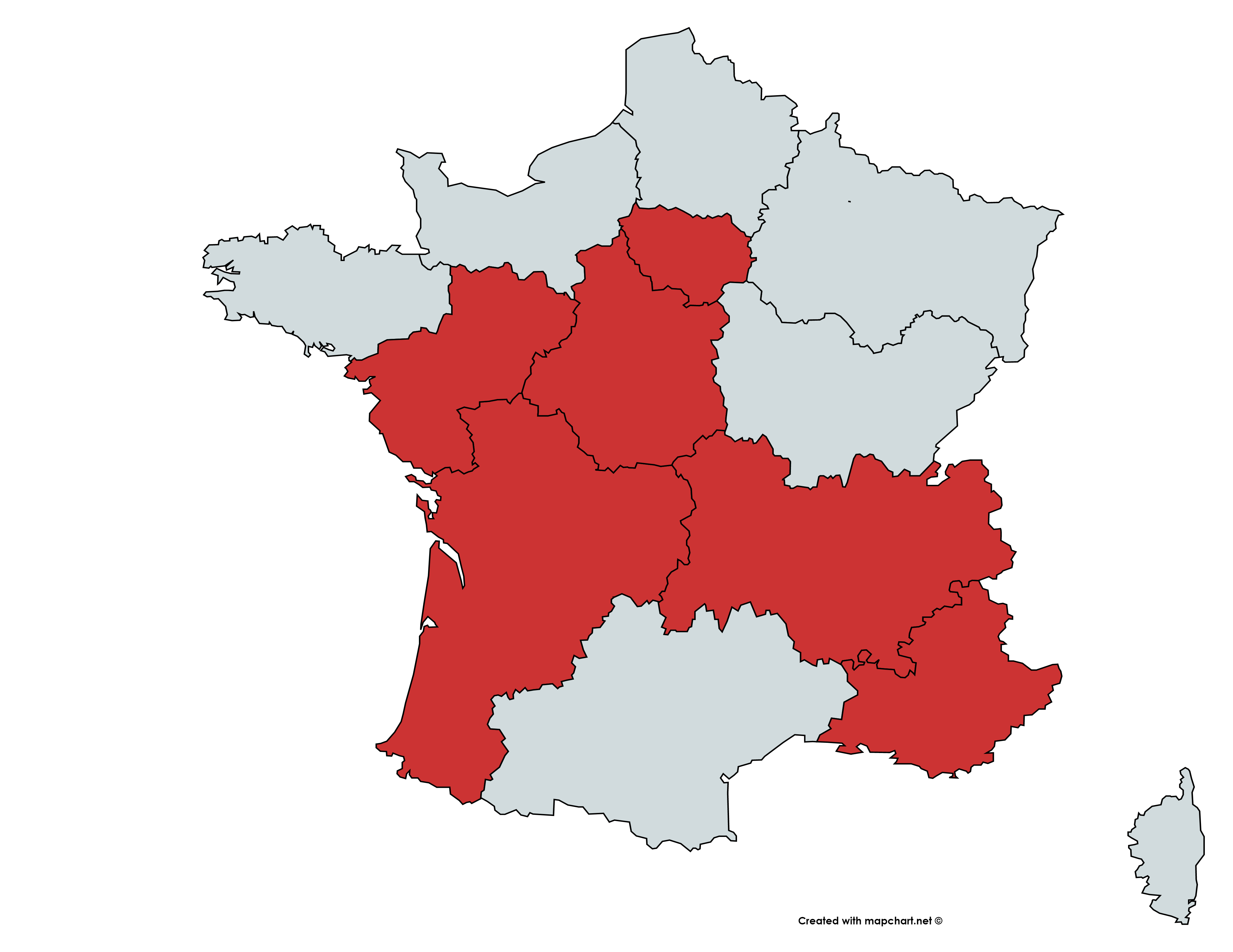
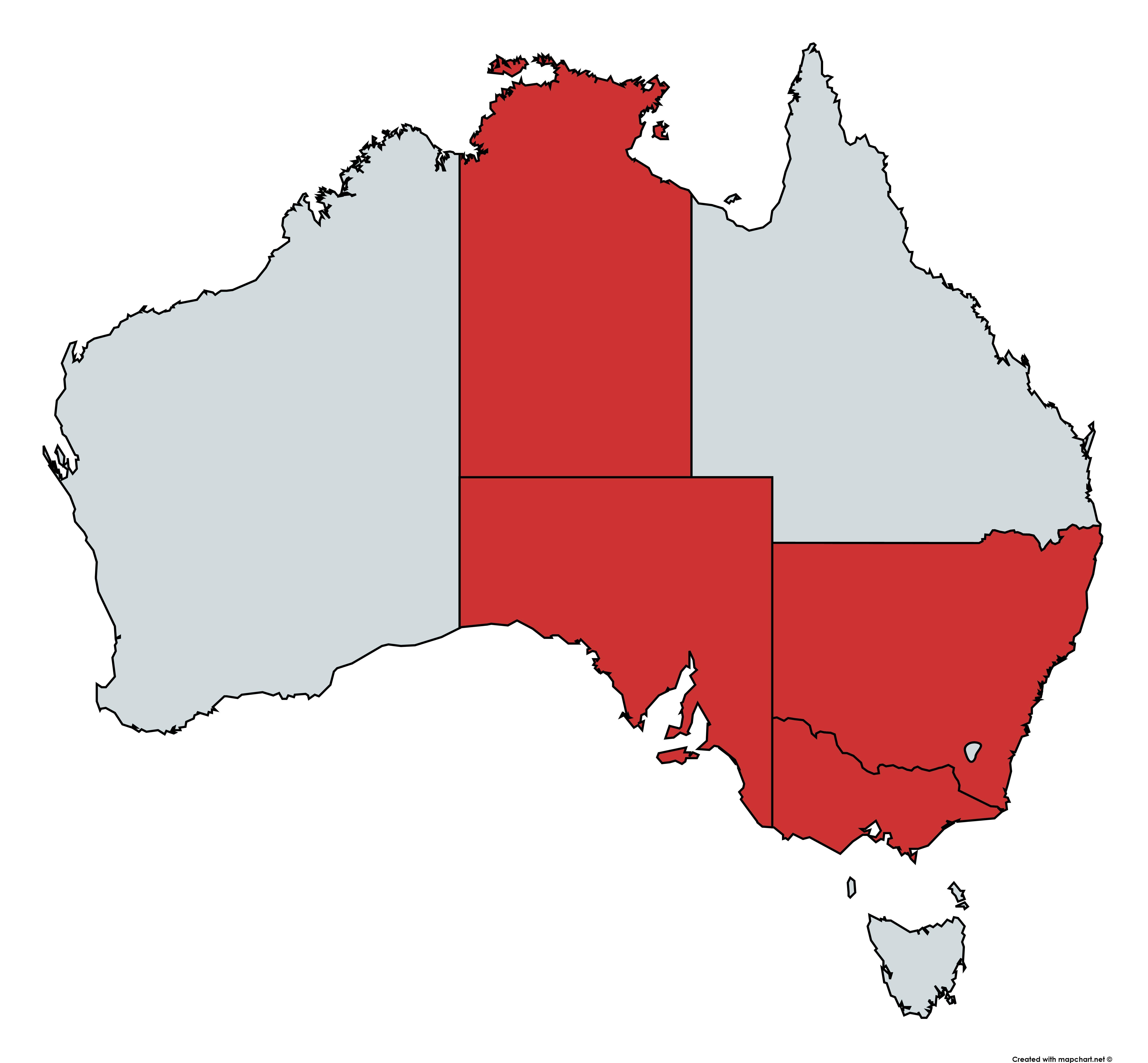
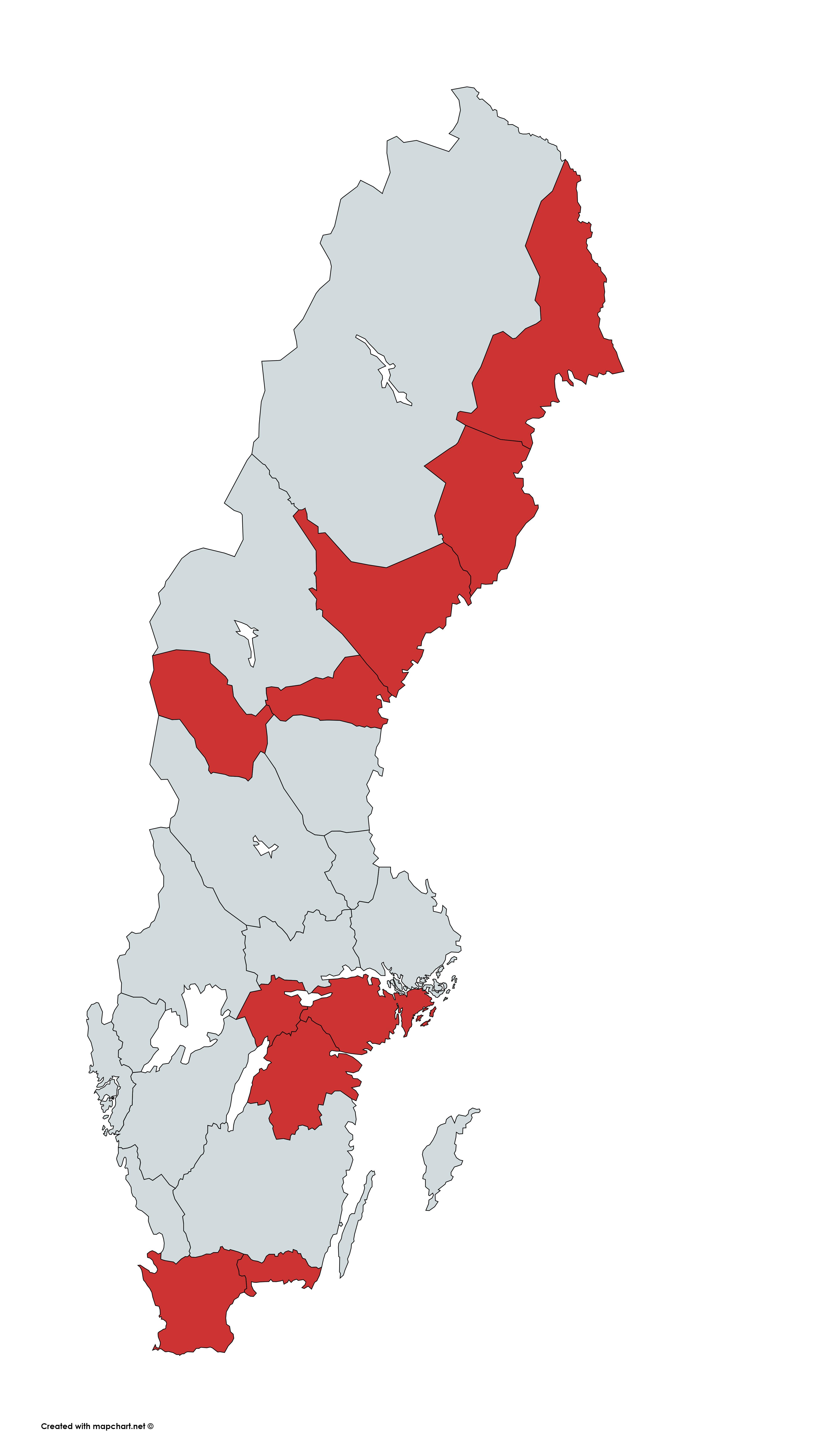
Map of France, part shaded Map of Australia, part shaded Map of Turkey, part shaded Map of Sweden, part shaded

Map of Brazil, no shading at all Map of Germany, part shaded Map of the Netherlands, part shaded

$\endgroup$

2 Answers 2

7
$\begingroup$

I believe Dave looks a bit shy and has been acting awkwardly in your presence because he's trying to say:

I LOVE YOU!

This is because in each image the highlighted states/provinces/regions...

...all contain one letter in common, and in fact for the most part comprise a complete list of all regions of that country which contain that letter.

  1. Brazil:

Federative units: Bahia, Espírito Santo, Goiás, Minas Gerais, Paraíba, Piauí, Rio de Janeiro, Rio Grande do Norte, Rio Grande do Sul, Rondônia, Roraima, Sergipe, and Tocantins. All of these contain the letter 'I'.

(However, Distrito Federal and Santa Catarina are omitted, possibly either by mistake or by consulting a slightly different source list?)

  1. France:

Administrative regions: Auvergne-Rhône-Alpes, Centre-Val de Loire, Île-de-France, Nouvelle-Aquitaine, Pays de la Loire, and Provence-Alpes-Côte d'Azur. All of these contain the letter 'L'.

  1. Australia:

States and territories: New South Wales, Northern Territory, South Australia, and Victoria. All of these contain the letter 'O'.

(The tiny east-coast Jervis Bay Territory may also be shaded here - it's hard to tell because it's so small! However, the Australian Capital Territory has been omitted, possibly because it has been considered as merely 'ACT'.)

  1. Turkey:

Provinces: Artvin, Nevşehir, Sivas, Van, and Yalova. All of these contain the letter 'V'.

  1. Sweden:

Provinces: Ångermanland, Blekinge, Härjedalen, Medelpad, Närke, Norrbotten, Östergötland, Skåne, Södermanland, and Västerbotten. All of these contain the letter 'E'.

(Västergötland is not shaded, however.)

  1. Brazil (again):

This time, no federative units of Brazil are shaded at all, since none of these contain the letter 'Y' in their names! (While this is also the case for 'Q' and 'X', for example, context of the other letters we are extracting suggests we should use 'Y' here in order for the final message to make sense...)

  1. Germany:

Federated states: Mecklenburg-Vorpommern, and Schleswig-Holstein. Both of these contain the letter 'O'.

(However, Nordrhein-Westfalen is omitted here. As are three states which include 'Saxony in the name, but this may be explained if instead their German names are used, which feature 'Sachsen' in its place, thereby containing no 'O'.)

  1. Netherlands:

Provinces: Limburg, Utrecht, and Zuid-Holland. All of these contain the letter 'U'.

Overall then...

...taking these derived letters in sequence spells out 'I LOVE YOU'.

EDIT: While editing the puzzle text to add alt text to the images, I just now discovered another thing that adds credence to this being the OP's intention... It isn't immediately obvious from the 'front end' of the puzzle, but from the 'back end' you can see that there are spaces left between the first-and-second and fifth-and-sixth map images, splitting the maps into three groups of size 1, 4 and 3. (Highlight the images using your mouse and see for yourself.) This suggests that the intended answer is of three words of these lengths, which 'I LOVE YOU' certainly satisfies!

A hat-tip to @Randal'Thor for his answer, since it was by perusing the names in the lists he'd extracted that I was able to spot the commonalities.

$\endgroup$
2
  • $\begingroup$ Stiv, You are a puzzle-solving machine! Also, is it pronounced with a short i sound, Stiv, or long i sound, Steve? $\endgroup$
    – JLee
    Commented May 10, 2022 at 13:07
  • 1
    $\begingroup$ @JLee Ha, thanks :) Sometimes these ones that have been hanging around for a while crop up in the 'Related' sidebar and something just clicks at long last. I rhyme Stiv with 'give'. $\endgroup$
    – Stiv
    Commented May 10, 2022 at 13:27
3
$\begingroup$

Partial answer: from images to codes

In Brazil (first time), the coloured regions are

Roraima (RR), Rondonia (RO), Tocantins (TO), Piaui (PI), Rio Grande do Norte (RN), Paraiba (PB), Goias (GO), Bahia (BA), Sergipe (SE), Minas Gerais (MG), Rio de Janeiro (RJ), Espírito Santo (ES), Rio Grande do Sul (RS). These are according to the official states of Brazil and the ISO standard codes.

In France, the coloured regions are

Pays de la Loire (PDL), Centre-Val de Loire (CVL), Ile-de-France (IDF), Nouvelle-Aquitaine (NAQ), Auvergne-Rhone-Alpes (ARA), Provence-Alpes-Cote d'Azur (PAC). Again these are according to the official regions of France and the ISO standard codes.

In Australia, the coloured regions are

Northern Territory (NT), South Australia (SA), New South Wales (NSW), Victoria (VIC). Again these are according to the official states/territories of Australia and the ISO standard codes.

In Turkey, the coloured regions are

Yalova (77), Nevşehir (50), Sivas (58), Artvin (8), Van (65). These are according to the ISO standard codes, this time numbers instead of letters.

In Sweden, the coloured regions are

Skåne (M/12), Blekinge (K/10), Östergötland (E/5), Örebro (T/18), Södermanland (D/4), Harjedalen, Medelpad, Angermanland, Vasterbotten, Norrbotten. This is complicated as there are different ways of dividing Sweden and the map shown in the OP here doesn't actually correspond to the counties used for ISO codes but instead to the historical provinces, which as far as I can tell don't have nice neat codes like ISO.

In Brazil (second time), there are no coloured regions.

In Germany, the coloured regions are

Schleswig-Holstein (SH) and Mecklenburg-Western Pomerania (MV), according to the states and their ISO codes.

In the Netherlands, the coloured regions are

South Holland (ZH), Utrecht (UT), and Limburg (LI), according to the official provinces and their ISO codes.

Now we have (more or less) a list of ISO codes. It remains to figure out what order to put them in and how to extract meaning from these sequences of letters and numbers.

$\endgroup$
3
  • $\begingroup$ Great effort! There is one thing I should mention, though. I think Dave considered provinces instead of Counties in Sweden. $\endgroup$
    – padawan
    Commented Aug 2, 2020 at 13:00
  • $\begingroup$ @padawan Sweden was the puzzling one indeed ... but using provinces rather blows my hope that the ISO codes would resolve to a nice cipher thing. Maybe I need to order all the subregions of each country in some way (area? population?) and allot them numbers accordingly, again to get some kind of ciphertext. The second Brazil is still puzzling though. $\endgroup$ Commented Aug 2, 2020 at 13:01
  • $\begingroup$ That's a clever take on puzzle, but maybe we can leave ISO codes out of it. $\endgroup$
    – padawan
    Commented Aug 2, 2020 at 13:17

Your Answer

By clicking “Post Your Answer”, you agree to our terms of service and acknowledge you have read our privacy policy.

Not the answer you're looking for? Browse other questions tagged or ask your own question.