Bounty Ended with 50 reputation awarded by paramesis
a captain's log updated (phase 3 solution)
Source Link
Thomas Blue
  • 7k
  • 30
  • 64

Long awaited, still partial, solution.Transmission from the moon radio-station

After a long time in space I started to forget what N and E stand for here, on Earth. Well, now it's clear to me: East and North are directions. The first time I tried to get through those Space Grids, I mixed them up and also tried to take clues from the spectrum... Oops, let me get the spoiler glasses on. I might talk something dangerous.

Same day, search expedition for the "Dear Friend", open space

That's all I- Captain! Thanks to the Phenomist's great job we've got the space maps translated from the radar.

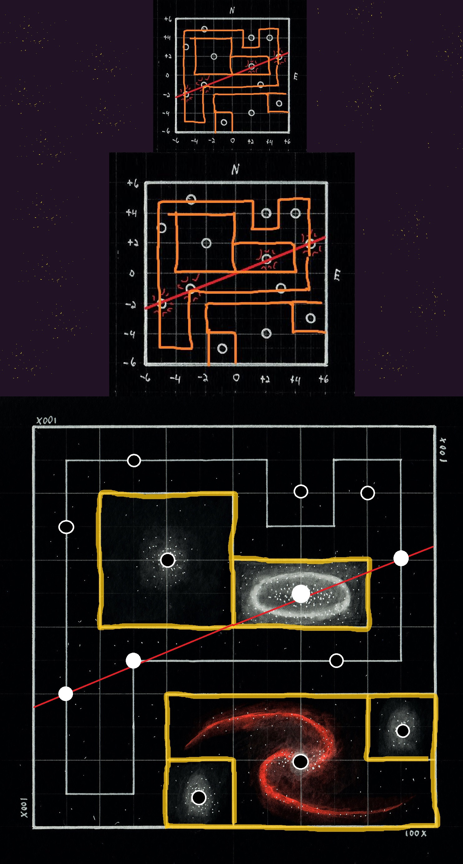
(looking through the maps) - Crap... Crap... Now this looks promising! Computer, gimme a close-up on the third map! And keep the radar information on it just in case.

- That's right... just a bit closer. See? For the first time in forever that "dear friend" might have provided us with valid information.

enter image description here

- And what would that mean? Do you get where to look for him now?

- I might have speculations, but nothing great enough to waste our fuel. I'd say - two versions. We can assume that the red dot might mean the Red Galaxy Center, which was photographed by the Friend. Thus, three points in a row might mean three stars of a single line - one black, one red and one white. What can be the white dot then?

If you pay attention to the order - black between white and red - you can assume that the star is THREE SPACEMILES NORTH, ONE SPACEMILE EAST from the R.G.C. It's within the beam, yet not precisely.

But you can forget the order - then it's obviously the famous collinear star, EIGHT SPACEMILES NORTH from the R.G.C. And if you're so dumb to consider black hole's center a white star, there is a couple more versions waiting at the Universe's edge.

- So where would we fly to get him, captain?

- We drift. Both of these versions still have a problem: 6 or 8 do not fit in them. I expected it to be the 3/4 angle of the line, as it was with the radar. But the 3/4 is too blunt - the angle is 0 for vertical and certainly no more than 1/2 for the scewed route. We still can't crack this spacenut on our own.

Long awaited, still partial, solution.

After a long time in space I started to forget what N and E stand for here, on Earth. Well, now it's clear to me: East and North are directions. The first time I tried to get through those Space Grids, I mixed them up and also tried to take clues from the spectrum... Oops, let me get the spoiler glasses on. I might talk something dangerous.

That's all I got,

Transmission from the moon radio-station

After a long time in space I started to forget what N and E stand for on Earth. Well, now it's clear to me: East and North are directions. The first time I tried to get through those Space Grids, I mixed them up and also tried to take clues from the spectrum... Oops, let me get the spoiler glasses on. I might talk something dangerous.

Same day, search expedition for the "Dear Friend", open space

- Captain! Thanks to the Phenomist's great job we've got the space maps translated from the radar.

(looking through the maps) - Crap... Crap... Now this looks promising! Computer, gimme a close-up on the third map! And keep the radar information on it just in case.

- That's right... just a bit closer. See? For the first time in forever that "dear friend" might have provided us with valid information.

enter image description here

- And what would that mean? Do you get where to look for him now?

- I might have speculations, but nothing great enough to waste our fuel. I'd say - two versions. We can assume that the red dot might mean the Red Galaxy Center, which was photographed by the Friend. Thus, three points in a row might mean three stars of a single line - one black, one red and one white. What can be the white dot then?

If you pay attention to the order - black between white and red - you can assume that the star is THREE SPACEMILES NORTH, ONE SPACEMILE EAST from the R.G.C. It's within the beam, yet not precisely.

But you can forget the order - then it's obviously the famous collinear star, EIGHT SPACEMILES NORTH from the R.G.C. And if you're so dumb to consider black hole's center a white star, there is a couple more versions waiting at the Universe's edge.

- So where would we fly to get him, captain?

- We drift. Both of these versions still have a problem: 6 or 8 do not fit in them. I expected it to be the 3/4 angle of the line, as it was with the radar. But the 3/4 is too blunt - the angle is 0 for vertical and certainly no more than 1/2 for the scewed route. We still can't crack this spacenut on our own.
Source Link
Thomas Blue
  • 7k
  • 30
  • 64

Long awaited, still partial, solution.

After a long time in space I started to forget what N and E stand for here, on Earth. Well, now it's clear to me: East and North are directions. The first time I tried to get through those Space Grids, I mixed them up and also tried to take clues from the spectrum... Oops, let me get the spoiler glasses on. I might talk something dangerous.

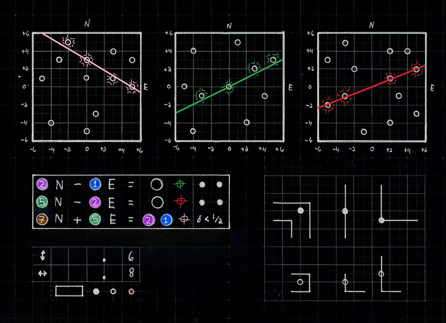
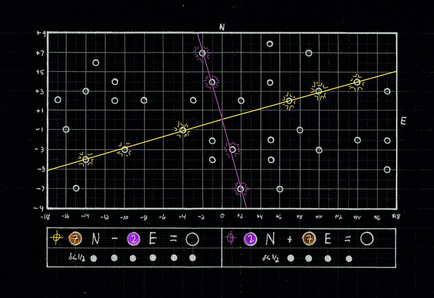
Allright, so the third slide is a classical

Space radar calibration table. The things beneath are linear equations with color-coded numbers. A linear equation describes a straight line and a dots beneath must be a number of stars in its vicinity (that's what I made out from classical d<1/2 expression - stars are counted if they are less than 1/2 spacemile from the beam).

Yet, not only you expect six stars on a line, not only you can assume that BLACK codes 0. There is also a nice twist: lines described as [ax+by=? and bx-ay=?] are perpendicular. This lets us calibrate a picture:

Beautiful.

Wonderful.

After that (if you didn't mix up the axis and spend an hour crying of helplessness) calibrating three radars on the second slide is relatively easy. I attach the image here:

Fascinating.

Now I'm pretty stumped, because radar calibrating data is about the half of your friend's transmission, and I can see no connection to the star-maps (or that little hint with arrows). Basically, the data I gathered, condenced, would be:

1)BLUE, 2)PURPLE, 5)GREEN, 7)ORANGE

There is one more thought on the main map, however, I don't know how to evolve it (also, what is the line across all the star-map? Is it a route of an ice-cream van? If so - is your friend an ice-cream merchant?)

I thought that six pieces on the minimap represent six different places on the star-map - like when you take a photo of a special crossing so you could be found later. Nevertheless, this seems not too probable - some pieces I can put to different places on the map, yet some of them don't seem to fit.

That's all I got,

SEE YOU SPACE COWBOY